@7mø.: #lionelmessi #argentina #worldcup #2022 #wc #final #2022 #fyp #viral #leo #messi #france

7mo
7mo
Open In TikTok:
Region: SA
Saturday 07 December 2024 19:17:58 GMT
1433208
168132
547
12465

Music

Download

Comments

ahmed.ashraf858
ahmed ashraf :
where is messi in the final 💀💀
2024-12-09 15:32:24
216
raremessi10
LM10 :
he turned up from the hero to the villian💀💀
2024-12-07 19:32:26
126
dark_bambaa
🔱 999 🔱 :
The Greatest Player Of All Time 🐐🇦🇷👽
2024-12-09 10:47:40
32
tutu.ba.dom
Taktoja :
From where is messi to rigged.
2024-12-10 01:51:39
8
mr.y300
مـوآسـ 🖤 :
The greatest 🔥🇦🇷
2024-12-08 10:17:53
24
stylishgirl.50
itsYaGirl_fxrhin :
messi is the goat
2024-12-13 17:08:39
4
free.palestine.1211
Kurt_Nada :
goated Edit like Messi ..
2024-12-08 21:32:01
7
georgia_anto4
georgia_anto :
GOAT💙💙💙
2024-12-09 18:41:46
5
imekir
.. :
The greatest performance and character of a player in a tournament in history
2024-12-08 20:55:44
3
kim.jeyung.he5
Kim jeyung he 💜 :
the goat Leo ☠️☠️☠️🗿🗿
2024-12-10 07:29:51
5
cَrَ9
حٰيدّر 🇵🇹 :
best duo in football ronaldo and messi
2024-12-08 12:28:39
6
parvez41932
🎀 P͟A͟ʀV͟E͟ᴢ 🎀 :
The greatest player in the world 💪🌍
2024-12-18 05:33:04
1
shipu8427
🎀~° :
𝐁𝐨𝐬𝐬 𝐋𝐞𝐨 ✨🩷
2024-12-18 07:17:22
2
md.kowcher.ahamme
MD Kowcher Ahammed :
the Best player of the world 🥰 LM 10 🥱
2024-12-08 12:20:44
5
princebadhon366
꧁༺💔ɮʀօӄɛռ քʀɨռƈɛ💔༻꧂ :
2 years world cup champion vmos Argentina 🇦🇷🇧🇩
2024-12-18 08:44:39
1
naziaaaaaaaaaaaaaaaa5
KOSEM🇦🇷🇦🇷💫 🇦🇷🇦🇷 :
what a video!!!😫
2024-12-18 06:49:33
1
apaksksozoxosksks
xpxndmksksoslsks :
that's the reasson why everyone said Messi is real goat age is not matter for her he always perform best 🗿🔥❤
2024-12-18 06:03:02
1
sifatalwaysonfire07m
👑 SIFAT 🇦🇷 :
Boos Messi 🗿🗿
2024-12-22 12:05:11
1
cabdulaahiyusufmcalin
CABDULAAHI :
2022 /12/18/2024/12/18💀💀💀💀
2024-12-18 07:53:43
1
mehedi.vai085
mehedi_vai :
Please give video editing tutorial 🙏
2024-12-18 07:10:56
2
To see more videos from user @7mø., please go to the Tikwm homepage.

Other Videos

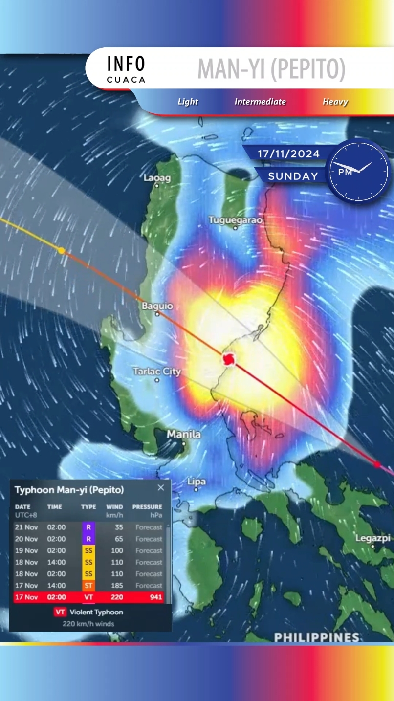
Man-yi (Philippine name Pepito, Japanese Typhoon Number 24) is located 304 km east of Manila, Philippines, and has tracked west-northwestward at 17 km/h (9 knots) over the past 6 hours. Maximum significant wave height is 12.2 meters (40 feet). Man-yi is forecast to continue tracking northwestward along the southwestern edge of the subtropical ridge to the northeast over the next 12 hours as it approaches the eastern coast of Luzon. Landfall is expected to occur right the next 12 hours near Baler. After Man-yi emerges in the South China Sea, ridging that extends westward over to Hong Kong will become the primary steering mechanism that will drive the system further northwestward though the next 36 hours. In around 36 hours, a strong cold surge flowing southwestward near Taiwan will prevent the vortex from gaining latitude. A westward track is forecast to persist over the next 3 days. In 3 days, Man-yi will turn more southwestward as it follows the low-level steering pattern as it dissipates. Regarding intensity, Man-yi is forecast to slightly degrade, but still make landfall at 185–205 km/h (100–110 knots) in around 12 hours. Terrain interaction over Luzon will rapidly weaken the system and borderline typhoon intensity is expected as it enters the South China Sea. Increasing wind shear along with the cold dry air brought in from the cold surge will inhibit any chances for intensification as the system tracks westward. In around 3 days, the environment quickly worsens due to shear increasing to around 65 km/h (35 knots) and dry air entraining into the core. As a result, dissipation south of Hainan is forecast in around 4 days. Model guidance is in good agreement over the next 2 days. A 26 km cross-track spread at the time of landfall opens to around 185 km/h (100 knots) at 2 days. After 2 days, models begin to diverge due to differences in the timing of dissipation and the sharpness of the southwestward turn. The JTWC track forecast is placed close to consensus through the entire forecast period with high confidence over the next 2 days and low confidence thereafter. Intensity guidance is in moderate agreement with an even spread of about 30–35 km/h (15–20 knots) throughout the forecast. The JTWC intensity forecast is placed slightly higher than consensus over the next 2 days and then slightly lower thereafter with overall medium confidence. Warning Number 32. Information provided by the Joint Typhoon Warning Center (JTWC). #infocuaca #typhoon #typhoonalert #manyi #typhoonmanyi #pepito #typhoonpepito #2024typhoon #philippines #manila #labo #daet #calauag #polilloisland #burdeos #panukulan #dingalan #cabanatuancity #sanjosecity #carranglan #mariaaurora #aritao #bambang #baguio #baguiocity #dagupan #bolinao #bacnotan #tagudin #latrinidad #sanfernando #upto220kmh #strongwinds #flood #evacuatenow #staysafe #pray4philippines🇵🇭

About