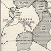
@ughistory: In the early 20th century, as the British tightened their grip on East Africa, the map of Uganda was anything but fixed. The colonial administrators, sitting in faraway offices in London and Nairobi, viewed Uganda not as a nation but as a patchwork of regions to be rearranged for administrative convenience. In 1902, they made their first major decision, slicing off Uganda’s eastern territories—including Kisumu and large parts of what is now western Kenya—and transferring them to the East Africa Protectorate. The reason was simple: the Uganda Railway, which snaked its way from Mombasa to Lake Victoria, needed to be managed under one jurisdiction, and Kenya seemed the logical choice. What mattered to the British was efficiency, not the fate of the communities suddenly finding themselves under new colonial masters. Twelve years later, in 1914, the colonial boundaries shifted again, this time in the north. A portion of Uganda’s northwestern lands near the River Nile and Lake Albert was handed over to Sudan, while another piece of Sudanese land was folded into Uganda. The reasons were not well explained, but it was clear that the British were still refining their colonial borders, balancing economic interests and the ease of governance. The local chiefs and elders had little say in these decisions—maps were drawn in offices, lines were sketched across vast territories, and people awoke to find themselves subjects of a different protectorate. These adjustments, though seemingly minor at the time, planted the seeds for future disputes and grievances. But the biggest blow came in 1926. Once again, Uganda lost land to Kenya, this time in the northeastern Rift Valley. The Turkana and Karamoja regions, rich in cattle and home to resilient pastoralist communities, were deemed too troublesome for Uganda’s administration and better suited for Kenya’s governance. The British, obsessed with making their rule more manageable, redrew the lines yet again. By then, Ugandans had begun to sense that their country was being carved up at the whims of colonial authorities. While no resistance emerged strong enough to challenge the British, the memory of these border changes would linger, shaping future grievances about land and identity in the decades to come. By the time the dust settled, Uganda’s map had taken a form that would remain largely unchanged for the rest of the colonial period. The Berlin Conference of 1884-85 had allowed Europeans to claim vast African territories, but it had not dictated the finer details of borders. Those details were worked out over the following decades, and Uganda had been among the most affected. Its leaders and people had no voice in these changes, yet they would live with the consequences for generations. The borders drawn in boardrooms would one day become national frontiers, and the lands lost would never return. #ugandanstiktok #ugandarailway #kenyantiktok🇰🇪 #kenyantiktok #kenyantiktok #kenya #uganda #ughistory #colonialism #britishEastAfrica #turkanatiktokers🥰 #turkana #kampala_tiktokers

UgHistory
UgHistory
Open In TikTok:
Region: KE
Wednesday 29 January 2025 14:35:53 GMT
95171
1447
155
332

Music

Download

Comments

leejamesbron
Billy Jimmy :
mimi ni pokot i can't imagine ningekuwa sahi za banange banange kwagalanyoo
2025-01-30 07:55:53
40
paul_fallah
Paul_fallah :
We can see here that Rwanda was Part of RDC. We are brothers so why RW is killing in DRC?? We can reunite the 2 countries and people 😅
2025-01-30 12:50:50
13

khalayiwema
Wema :
no as someone from that part....we're good as kenyans 😁😁😁
2025-01-30 06:13:10
30
maxkodi1
Max :
So ur telling me I was very close to not been able to speak Swahili. I’m glad I ended up Kenyan 😂
2025-01-31 23:58:55
4
user246926239944operator
user246926239944dan wanjala :
I love Kenya I don't want to go to museven
2025-11-13 20:27:06
1
thathinihiuu9
thathini ⚔️ :
western,Nyanza Na part Rift valley wangekuwa Uganda, northern Eastern to Somali,coast to Tanzania hii shida Kenya hatungekuwa nayo only central province peke ndio Kenya 🤣🤣🤣
2025-01-30 10:26:19
10
staccuz
Okoth :
Si mchukue kama ni yenu... mnatusumbua
2025-01-29 19:03:14
21
githiorahmaguru
githiorahmaguru🇵🇷🇵🇷 :
no wonder hawa watu wa western na Nyanza wanasumbua hivyo. kumbe hata siyo wakenya??🤔🤔🙄🙄🙄
2025-01-30 06:57:13
17
theafricanprofessor
The African Professor :
yaani ningekuwa mganda, interesting 😂
2025-01-29 18:41:30
4

safana8306
safana :
we had bûrûri WA kîrînyaga. ie the Kikuyu land
2025-01-30 19:02:43
3
northsea99
️ :
kujeni tuzichape
2025-01-30 12:48:28
0

mache.hardwares.nku
Mache Hardware Stores :
aaaaah take it then 😂😂
2025-01-31 08:34:22
0
oghubofficial
OG Hub :
njaa ikiuma unaanza kuona majirani zako ndio sababu ya wewe kuwa na njaa 😂😂
2025-01-30 07:38:03
0
user8646822483255
Ogega jnr :
😄😄😄
2025-02-05 06:37:05
0

richardokuba
richardokuba :
🥰
2025-11-13 21:19:39
0
user42599614377965
躺在你的梨渦裡(我的ㄌㄞ:423tbb) :
2025-04-01 18:56:22
0
kaware85
user7669771286503 :
😂😂😂
2025-02-03 11:34:06
0
yayazelubabel
Hyaceinthe Ngwijabagabo :
😅😅😅
2025-03-04 22:07:43
0
a.y.i.e.k.o.f.e.l.i.x
f h :
😁😁😁
2025-01-29 23:17:10
0
big.brother953
big brother :
🥰🥰🥰
2025-02-06 05:51:19
0
kosh2946
Kosh :
before the pink people came those imaginary lines didn't exist...they divided us to rule us
2025-01-30 07:22:01
7
shynick32
Jamal khashogi :
this territory belonged to tribes and not Uganda. if you want land go and ask the German government.
2025-01-30 04:19:35
3
djglenr
Dj_glen._ :
hatungekuwa na kasongo. we would be lucky.😅😅 goddammit
2025-02-01 14:24:58
2
denniswokorach
LIÆM 👨‍💻🤴🏼 :
Biggest broad day theft by the British. Most of Uganda's land given away imagine😳😳
2025-01-30 06:34:49
3
lets_drink
Wine o'clock :
the only map that makes sense tribe wise. considering how people in the shaded parts speak similar languages to the people along the current Uganda border.
2025-01-30 14:44:10
1
To see more videos from user @ughistory, please go to the Tikwm homepage.

Other Videos


About