@theindiacouple:

theindiacouple
theindiacouple
Open In TikTok:
Region: DK
Tuesday 26 August 2025 12:11:25 GMT
324
67
0
0

Music

Download

Comments

There are no more comments for this video.
To see more videos from user @theindiacouple, please go to the Tikwm homepage.

Other Videos

Tropical Storm Kajiki has intensified into a typhoon, and peak sustained winds have risen to 120km/h, with gusts of 148.  Kajiki’s outer bands have now reached the Chinese province of Hainan, and by 2:00 pm today, the inner core of the storm is forecast to strike the southern portion of the province, bringing powerful winds and torrential rainfall.  Latest model guidance has pushed the high-end of the forecast range even further for southern Hainan, 130 to 160km/h was mentioned in the 3rd analysis of this storm, but is now upgraded slightly, to 130 to 170km/h.  The most violent conditions are expected to occur from Lingshui to Sanya, to Yazhou, from 2:00 pm until 10:00 pm.  Seek shelter, avoid traveling.  Roads may become blocked due to uprooted trees or other debris, buildings may sustain moderate to considerable damage, and vehicles may be overturned.  Extreme rainfall totals of 5 to 9 inches is forecast, with locally up to 14 inches possible over the southern province.  Extreme rainfall rates may cause life-threatening flash flooding and landslides.  Kajiki is far from finished once past Hainan though.  The storm is then moving over the warm waters of the Gulf of Tonkin Sunday night, and is forecast to intensify.  How much Kajiki will intensify, is still a topic for debate, as ECMWF and ICON both share ugly scenarios, even showing the risk for the system upgrading into a T6 typhoon (Category 4 equivalent) prior to slamming Vietnam.  GFS is more modest on the other hand, projecting Kajiki to upgrade to a low-end T5 storm (Category 2 equivalent) prior to landfall.  That said, we expect Kajiki will intensify into a high-end T5 typhoon, with risk of the storm reaching T6 intensity, with forecasted peak sustained winds of 180 to 220km/h by 10:00 am Monday.  The storm slams ashore in the north central coast region of Vietnam directly after reaching maximum intensity, bringing life-threatening typhoon conditions, lasting into Monday evening.  From Dong Hoi to Hoang Mai, and all municipalities in between, peak wind gusts of 160 to 200km/h are now forecasted, which is also a slight increase from the last analysis.  Destructive winds causing considerable to severe structural damage is possible in these areas.  Many roads will likely be closed due to debris, widespread tree damage is expected.  Travel is strictly discouraged, as vehicles can be overturned or crushed under falling trees and debris under such conditions.  Rainfall is also of high concern, with torrential rainfall rates of 2 inches per hour or more expected, with rainfall totals ranging between 8 to 14 inches, with risk of 18 inches or more locally.  Severe, life-threatening flash flooding is expected. Landslides and debris flows are possible in areas of steep terrain.  The next update will be posted by 4:00 am Monday, August 25th, ICT. Stay tuned! #typhoonkajiki #Kajiki #Typhoon #Hainan #Vietnam
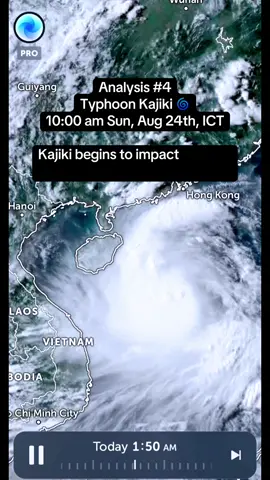
Tropical Storm Kajiki has intensified into a typhoon, and peak sustained winds have risen to 120km/h, with gusts of 148. Kajiki’s outer bands have now reached the Chinese province of Hainan, and by 2:00 pm today, the inner core of the storm is forecast to strike the southern portion of the province, bringing powerful winds and torrential rainfall. Latest model guidance has pushed the high-end of the forecast range even further for southern Hainan, 130 to 160km/h was mentioned in the 3rd analysis of this storm, but is now upgraded slightly, to 130 to 170km/h. The most violent conditions are expected to occur from Lingshui to Sanya, to Yazhou, from 2:00 pm until 10:00 pm. Seek shelter, avoid traveling. Roads may become blocked due to uprooted trees or other debris, buildings may sustain moderate to considerable damage, and vehicles may be overturned. Extreme rainfall totals of 5 to 9 inches is forecast, with locally up to 14 inches possible over the southern province. Extreme rainfall rates may cause life-threatening flash flooding and landslides. Kajiki is far from finished once past Hainan though. The storm is then moving over the warm waters of the Gulf of Tonkin Sunday night, and is forecast to intensify. How much Kajiki will intensify, is still a topic for debate, as ECMWF and ICON both share ugly scenarios, even showing the risk for the system upgrading into a T6 typhoon (Category 4 equivalent) prior to slamming Vietnam. GFS is more modest on the other hand, projecting Kajiki to upgrade to a low-end T5 storm (Category 2 equivalent) prior to landfall. That said, we expect Kajiki will intensify into a high-end T5 typhoon, with risk of the storm reaching T6 intensity, with forecasted peak sustained winds of 180 to 220km/h by 10:00 am Monday. The storm slams ashore in the north central coast region of Vietnam directly after reaching maximum intensity, bringing life-threatening typhoon conditions, lasting into Monday evening. From Dong Hoi to Hoang Mai, and all municipalities in between, peak wind gusts of 160 to 200km/h are now forecasted, which is also a slight increase from the last analysis. Destructive winds causing considerable to severe structural damage is possible in these areas. Many roads will likely be closed due to debris, widespread tree damage is expected. Travel is strictly discouraged, as vehicles can be overturned or crushed under falling trees and debris under such conditions. Rainfall is also of high concern, with torrential rainfall rates of 2 inches per hour or more expected, with rainfall totals ranging between 8 to 14 inches, with risk of 18 inches or more locally. Severe, life-threatening flash flooding is expected. Landslides and debris flows are possible in areas of steep terrain. The next update will be posted by 4:00 am Monday, August 25th, ICT. Stay tuned! #typhoonkajiki #Kajiki #Typhoon #Hainan #Vietnam

About